Файл:Larissa map.gif

Исходный файл (320 × 596 пкс, размер файла: 81 Кб, MIME-тип: image/gif)
Краткое описание[править | править код]
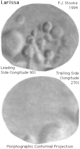
Карта передней и задней сторон Лариссы.[1]
Shaded relief map of Larissa, a small inner satellite of Neptune. As with all maps, it is the cartographer's interpretation and not all features are necessarily certain given the limited data available - this interpretation stretches the data as far as is feasible. The original map was published in its full form with latitude-longitude grid and feature names, in:
Stooke, P.J., 1994. "The Surfaces of Larissa and Proteus", EARTH, MOON AND PLANETS, V. 65, pp. 31-54.
Positions in the map are controlled by a digital shape model, described in that paper. The shape data for Larissa are very limited. For this map, the three dimensional convex hull of the shape model was projected into the Morphographic Conformal Projection (the conventional Stereographic Projection modified for non-spherical worlds). The leading side (longitude 90 runs vertically down the centre) faces forwards in the orbit of Larissa. The trailing side (longitude 270 runs vertically down its centre) faces backwards along the orbit. Longitude 0 is at the righthand end of the leading side, and faces Neptune. As with all conformal (true shape) projections, the scale in these maps varies, increasing from the centre to the outer edge.
The map projection is described in:
Stooke, P.J. and Keller, C.P., 1990. "Map Projections for Non-Spherical Worlds / the Variable-Radius Map Projections", CARTOGRAPHICA, V. 27, No. 2, pp. 82-100.
Источник: File:Larissa map.gif.
Лицензирование[править | править код]
| Этот файл общественное достояние. Это значит, что либо истекли сроки действия имущественных прав, либо файл был изначально передан в общественное достояние правообладателем Файлы с этой лицензией можно найти здесь. |
История файла
Нажмите на дату/время, чтобы увидеть версию файла от того времени.
| Дата/время | Миниатюра | Размеры | Участник | Примечание | |
|---|---|---|---|---|---|
| текущий | 00:19, 21 февраля 2022 | | 320 × 596 (81 Кб) | Aqui (обсуждение | вклад) | Shaded relief map of Larissa, a small inner satellite of Neptune. As with all maps, it is the cartographer's interpretation and not all features are necessarily certain given the limited data available - this interpretation stretches the data as far as… |
Вы не можете перезаписать этот файл.
Использование файла
Следующая страница использует этот файл: